
Xaimont topographic map
Interactive map
Click on the map to display elevation.
About this map
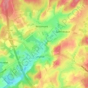
Name: Xaimont topographic map, elevation, terrain.
Location: Xaimont, Léglise, Neufchâteau, Luxemburg, Wallonië, 6860, België (49.78611 5.52094 49.82611 5.56094)
Average elevation: 430 m
Minimum elevation: 384 m
Maximum elevation: 474 m
Other topographic maps
Click on a map to view its topography, its elevation and its terrain.
Anlier
België > Luxemburg > Neufchâteau > Léglise
Anlier, Léglise, Neufchâteau, Luxemburg, Wallonië, België
Average elevation: 459 m