
Cove topographic map
Click on the map to display elevation.
About this map
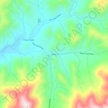
Name: Cove topographic map, elevation, terrain.
Location: Cove, Haywood County, North Carolina, United States (35.65594 -82.96014 35.69594 -82.92014)
Average elevation: 925 m
Minimum elevation: 747 m
Maximum elevation: 1,309 m
Other topographic maps
Click on a map to view its topography, its elevation and its terrain.
Waynesville
United States > North Carolina > Haywood County
Most of the town of Waynesville lies between 2,600 and 3,000 feet (790 and 910 m) above sea level, in a valley among 5,000-to-6,410-foot (1,520 to 1,950 m) mountain peaks. With the high Great Balsam Mountains to the west-southwest, and the Plott Balsams to the west-northwest, a handful of peaks over 6000' in…
Average elevation: 921 m
Cataloochee Valley Viewpoint
United States > North Carolina > Haywood County > Cataloochee
Average elevation: 1,058 m
Waynesville
United States > North Carolina > Haywood County
Most of the town of Waynesville lies between 2,600 and 3,000 feet (790 and 910 m) above sea level, in a valley among 5,000-to-6,410-foot (1,520 to 1,950 m) mountain peaks. With the high Great Balsam Mountains to the west-southwest, and the Plott Balsams to the west-northwest, a handful of peaks over 6000' in…
Average elevation: 921 m