
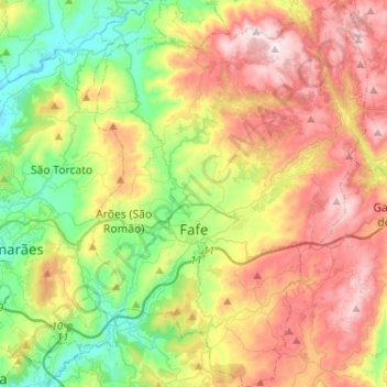
Fafe topographic map
Interactive map
Click on the map to display elevation.
About this map
Name: Fafe topographic map, elevation, terrain.
Location: Fafe, Braga, Portugal (41.37283 -8.24796 41.56595 -8.05519)
Average elevation: 450 m
Minimum elevation: 122 m
Maximum elevation: 885 m
Other topographic maps
Click on a map to view its topography, its elevation and its terrain.
Mosteiro
Portugal > Braga > Vieira do Minho
Mosteiro, Vieira do Minho, Braga, Portugal
Average elevation: 436 m
Moinho Velho
Portugal > Braga > Vila Verde
Moinho Velho, Vila Verde, Braga, 4730-190, Portugal
Average elevation: 290 m
Nespereira
Nespereira, Guimarães, Braga, 4811-909, Portugal
Average elevation: 242 m