
Make a donation
Gear up for your next adventure:
As an Amazon Associate, this site earns from qualifying purchases at no extra cost to you.
Lahntal topographic map
Click on the map to display elevation.
Make a donation
Gear up for your next adventure:
As an Amazon Associate, this site earns from qualifying purchases at no extra cost to you.
Lahntal
Die Lahn flussabwärts von Westen nach Osten betrachtet gehören Brungershausen, Kernbach und Caldern naturräumlich zum Oberen Lahntal, während Sterzhausen, Goßfelden, Sarnau und Göttingen in der Wetschaft-Senke liegen. Das Obere Lahntal ist die nördliche Nahtstelle des Gladenbacher Berglandes zu den Ausläufern des Rothaargebirges (Wittgensteiner Bergland und Sackpfeife nebst Vorhöhen).
Make a donation
Gear up for your next adventure:
As an Amazon Associate, this site earns from qualifying purchases at no extra cost to you.
About this map
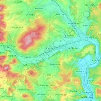
Name: Lahntal topographic map, elevation, terrain.
Average elevation: 276 m
Minimum elevation: 177 m
Maximum elevation: 488 m
Make a donation
Gear up for your next adventure:
As an Amazon Associate, this site earns from qualifying purchases at no extra cost to you.
Other topographic maps
Click on a map to view its topography, its elevation and its terrain.
Wallau (Lahn)
Deutschland > Hessen > Landkreis Marburg-Biedenkopf > Biedenkopf > Wallau (Lahn)
Average elevation: 371 m
Neustadt (Hessen)
Deutschland > Hessen > Landkreis Marburg-Biedenkopf > Neustadt
Average elevation: 292 m
Make a donation
Gear up for your next adventure:
As an Amazon Associate, this site earns from qualifying purchases at no extra cost to you.
Hinterstein
Deutschland > Hessen > Landkreis Marburg-Biedenkopf > Breidenbach
Average elevation: 367 m
Make a donation
Gear up for your next adventure:
As an Amazon Associate, this site earns from qualifying purchases at no extra cost to you.
Bracht-Siedlung
Deutschland > Hessen > Landkreis Marburg-Biedenkopf > Rauschenberg
Average elevation: 290 m
Hartenrod
Deutschland > Hessen > Landkreis Marburg-Biedenkopf > Bad Endbach
Die Statistisch-topographisch-historische Beschreibung des Großherzogthums Hessen berichtet 1830 über Hartenrod.
Average elevation: 422 m
Günterod
Deutschland > Hessen > Landkreis Marburg-Biedenkopf > Bad Endbach
Kreuzungspunkt alter Höhenwege mit Turmburg
Average elevation: 396 m
Make a donation
Gear up for your next adventure:
As an Amazon Associate, this site earns from qualifying purchases at no extra cost to you.
Am Kleeberg
Deutschland > Hessen > Landkreis Marburg-Biedenkopf > Biedenkopf > Ludwigshütte
Average elevation: 359 m
Make a donation
Gear up for your next adventure:
As an Amazon Associate, this site earns from qualifying purchases at no extra cost to you.
Dilschhausen
Deutschland > Hessen > Landkreis Marburg-Biedenkopf > Marburg > Dilschhausen
Average elevation: 301 m
Niederwetter
Deutschland > Hessen > Landkreis Marburg-Biedenkopf > Wetter > Niederwetter
Average elevation: 235 m
Mellnauer Kreuz
Deutschland > Hessen > Landkreis Marburg-Biedenkopf > Wetter > Mellnau
Average elevation: 344 m
Make a donation
Gear up for your next adventure:
As an Amazon Associate, this site earns from qualifying purchases at no extra cost to you.
Rüchenbach
Deutschland > Hessen > Landkreis Marburg-Biedenkopf > Rüchenbach
Die Statistisch-topographisch-historische Beschreibung des Großherzogthums Hessen berichtet 1830 über Rüchenbach.
Average elevation: 280 m
Make a donation
Gear up for your next adventure:
As an Amazon Associate, this site earns from qualifying purchases at no extra cost to you.