
Općina Dubrava topographic map
Interactive map
Click on the map to display elevation.
About this map
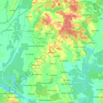
Name: Općina Dubrava topographic map, elevation, terrain.
Location: Općina Dubrava, Gespanschaft Zagreb, 10342, Kroatien (45.77402 16.43450 45.90299 16.62348)
Average elevation: 117 m
Minimum elevation: 95 m
Maximum elevation: 167 m
Other topographic maps
Click on a map to view its topography, its elevation and its terrain.
Općina Jakovlje
Kroatien > Gespanschaft Zagreb
Općina Jakovlje, Gespanschaft Zagreb, 10297, Kroatien
Average elevation: 177 m
Poljanak
Kroatien > Gespanschaft Zagreb
Poljanak, Grad Samobor, Gespanschaft Zagreb, 10456, Kroatien
Average elevation: 726 m