
Općina Jakovlje topographic map
Interactive map
Click on the map to display elevation.
About this map
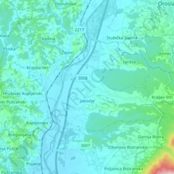
Name: Općina Jakovlje topographic map, elevation, terrain.
Location: Općina Jakovlje, Gespanschaft Zagreb, 10297, Kroatien (45.92030 15.81692 45.97549 15.96037)
Average elevation: 177 m
Minimum elevation: 124 m
Maximum elevation: 669 m
Other topographic maps
Click on a map to view its topography, its elevation and its terrain.
Općina Dubrava
Kroatien > Gespanschaft Zagreb
Općina Dubrava, Gespanschaft Zagreb, 10342, Kroatien
Average elevation: 117 m
Poljanak
Kroatien > Gespanschaft Zagreb
Poljanak, Grad Samobor, Gespanschaft Zagreb, 10456, Kroatien
Average elevation: 726 m