Geolocate

Downham topographic map

Click on the map to display elevation.

About this map

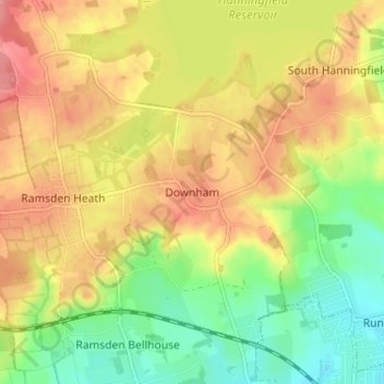
Name: Downham topographic map, elevation, terrain.

Location: Downham, Chelmsford, Essex, England, CM11 1QN, United Kingdom (51.61757 0.47355 51.65757 0.51355)

Average elevation: 50 m

Minimum elevation: 9 m

Maximum elevation: 87 m

Other topographic maps

Click on a map to view its topography, its elevation and its terrain.

Broomfield

United Kingdom > England > Essex > Chelmsford

Average elevation: 47 m

Rettendon

United Kingdom > England > Essex > Chelmsford > Rettendon

Average elevation: 26 m

College Wood

United Kingdom > England > Essex > Chelmsford

Average elevation: 42 m

Roxwell

United Kingdom > England > Essex > Chelmsford > Roxwell

Average elevation: 56 m

Springfield

United Kingdom > England > Essex > Chelmsford

Average elevation: 42 m

Sandon

United Kingdom > England > Essex > Chelmsford > Sandon

Average elevation: 41 m

West Hanningfield

United Kingdom > England > Essex > Chelmsford

Average elevation: 56 m

Gear up for your next adventure:

📡Satellite Messengers - Emergency communication devices
🎨Portable Watercolor Kits - Paint the landscapes and topographic views you discover
🧥Packable Rain Jackets - Breathable waterproof layers for unpredictable mountain weather
📖Australian Bush Survival Books - Local knowledge on finding water and surviving the outback
🥶Thermal Beanies - Warm hats for cold hikes

As an Amazon Associate, this site earns from qualifying purchases at no extra cost to you.