
Azuga topographic map
Interactive map
Click on the map to display elevation.
About this map
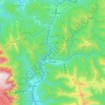
Name: Azuga topographic map, elevation, terrain.
Location: Azuga, Prahova, 105100, Romania (45.40969 25.53174 45.50063 25.71171)
Average elevation: 1,258 m
Minimum elevation: 826 m
Maximum elevation: 2,486 m
Other topographic maps
Click on a map to view its topography, its elevation and its terrain.
Valea Mantei
Romania > Prahova > Valea Mantei
Valea Mantei, Valea Călugărească, Prahova, 107631, Romania
Average elevation: 230 m
Valea Călugărească
Romania > Prahova > Valea Călugărească
Valea Călugărească, Prahova, Romania
Average elevation: 154 m