
Town of Guilderland topographic map
Interactive map
Click on the map to display elevation.
About this map
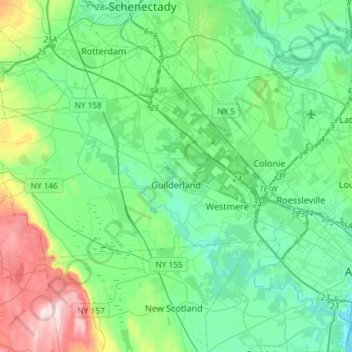
Name: Town of Guilderland topographic map, elevation, terrain.
Location: Town of Guilderland, Albany County, New York, United States (42.65915 -74.10672 42.76064 -73.81251)
Average elevation: 126 m
Minimum elevation: 2 m
Maximum elevation: 551 m
Other topographic maps
Click on a map to view its topography, its elevation and its terrain.
Albany
United States > New York > Albany County > Albany
The highest natural point in Albany is a USGS benchmark near the Loudonville Reservoir off Birch Hill Road, at 378 feet (115 m) above sea level. The lowest point is sea level at the Hudson River (the average water elevation is 2 feet (0.61 m)), which is still technically an estuary at Albany and is affected by…
Average elevation: 114 m