
Make a donation
Gear up for your next adventure:
As an Amazon Associate, this site earns from qualifying purchases at no extra cost to you.
Pickens County topographic map
Click on the map to display elevation.
Make a donation
Gear up for your next adventure:
As an Amazon Associate, this site earns from qualifying purchases at no extra cost to you.
Pickens County
Less than one-third of the county was developed for cotton plantations, which were worked by enslaved African-Americans brought south by northern businessmen interested in cheap cotton. These plantations were developed primarily in the southernmost reaches of the county, in the lowlands along the banks of the Tombigbee River and stretching over a small prairie-like area. The rest of the county was settled by yeomen farmers who held few slaves; it was topographically unsuited for plantation-scale farming operations.
Make a donation
Gear up for your next adventure:
As an Amazon Associate, this site earns from qualifying purchases at no extra cost to you.
About this map
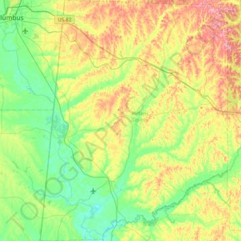
Name: Pickens County topographic map, elevation, terrain.
Location: Pickens County, Alabama, United States (32.99128 -88.34082 33.53397 -87.83630)
Average elevation: 78 m
Minimum elevation: 29 m
Maximum elevation: 181 m
Make a donation
Gear up for your next adventure:
As an Amazon Associate, this site earns from qualifying purchases at no extra cost to you.
Other topographic maps
Click on a map to view its topography, its elevation and its terrain.
Woodmere Park
United States > Alabama > Montgomery County > Montgomery > Bellwood Plantation
Average elevation: 84 m
Make a donation
Gear up for your next adventure:
As an Amazon Associate, this site earns from qualifying purchases at no extra cost to you.
Gulf Shores
United States > Alabama > Gulf Shores
Jack Edwards National Airport is located in Gulf Shores and offers services from Gulf Air Center, Salt Air Aviation Center and Platium Air Center. The airport is located in town, two miles from the beach. Their FBO Gulf Air Center will provide a rental vehicle while they take care of fueling and storing…
Average elevation: 6 m
Make a donation
Gear up for your next adventure:
As an Amazon Associate, this site earns from qualifying purchases at no extra cost to you.
Make a donation
Gear up for your next adventure:
As an Amazon Associate, this site earns from qualifying purchases at no extra cost to you.
Make a donation
Gear up for your next adventure:
As an Amazon Associate, this site earns from qualifying purchases at no extra cost to you.
Choccolocco Wildlife Management Area
United States > Alabama > Cleburne County
Average elevation: 370 m
Make a donation
Gear up for your next adventure:
As an Amazon Associate, this site earns from qualifying purchases at no extra cost to you.
Make a donation
Gear up for your next adventure:
As an Amazon Associate, this site earns from qualifying purchases at no extra cost to you.
Make a donation
Gear up for your next adventure:
As an Amazon Associate, this site earns from qualifying purchases at no extra cost to you.
Make a donation
Gear up for your next adventure:
As an Amazon Associate, this site earns from qualifying purchases at no extra cost to you.
Make a donation
Gear up for your next adventure:
As an Amazon Associate, this site earns from qualifying purchases at no extra cost to you.
Lake Ida
United States > Alabama > Limestone County > Athens > Lake Ida Heights
Average elevation: 218 m
Make a donation
Gear up for your next adventure:
As an Amazon Associate, this site earns from qualifying purchases at no extra cost to you.
Make a donation
Gear up for your next adventure:
As an Amazon Associate, this site earns from qualifying purchases at no extra cost to you.
Make a donation
Gear up for your next adventure:
As an Amazon Associate, this site earns from qualifying purchases at no extra cost to you.
Make a donation
Gear up for your next adventure:
As an Amazon Associate, this site earns from qualifying purchases at no extra cost to you.
Make a donation
Gear up for your next adventure:
As an Amazon Associate, this site earns from qualifying purchases at no extra cost to you.
Make a donation
Gear up for your next adventure:
As an Amazon Associate, this site earns from qualifying purchases at no extra cost to you.
Make a donation
Gear up for your next adventure:
As an Amazon Associate, this site earns from qualifying purchases at no extra cost to you.
Make a donation
Gear up for your next adventure:
As an Amazon Associate, this site earns from qualifying purchases at no extra cost to you.
Make a donation
Gear up for your next adventure:
As an Amazon Associate, this site earns from qualifying purchases at no extra cost to you.
Cheaha Mountain
United States > Alabama > Cleburne County
Cheaha Mountain is part of the Talladega Mountains, a small section of the Ridge and Valley Mountains, unlike other elevations of the Appalachians in north Alabama, which are part of the Cumberland Plateau. The mountain is the highest point in the eastern portion of the Sun Belt (east of the Mississippi River,…
Average elevation: 543 m
Make a donation
Gear up for your next adventure:
As an Amazon Associate, this site earns from qualifying purchases at no extra cost to you.
Make a donation
Gear up for your next adventure:
As an Amazon Associate, this site earns from qualifying purchases at no extra cost to you.
Make a donation
Gear up for your next adventure:
As an Amazon Associate, this site earns from qualifying purchases at no extra cost to you.
Make a donation
Gear up for your next adventure:
As an Amazon Associate, this site earns from qualifying purchases at no extra cost to you.
Make a donation
Gear up for your next adventure:
As an Amazon Associate, this site earns from qualifying purchases at no extra cost to you.
Make a donation
Gear up for your next adventure:
As an Amazon Associate, this site earns from qualifying purchases at no extra cost to you.
Cheaha Mountain
United States > Alabama > Cleburne County
Cheaha Mountain is part of the Talladega Mountains, a small section of the Ridge and Valley Mountains, unlike other elevations of the Appalachians in north Alabama, which are part of the Cumberland Plateau. The mountain is the highest point in the eastern portion of the Sun Belt (east of the Mississippi River,…
Average elevation: 543 m
Make a donation
Gear up for your next adventure:
As an Amazon Associate, this site earns from qualifying purchases at no extra cost to you.