
Make a donation
Gear up for your next adventure:
As an Amazon Associate, this site earns from qualifying purchases at no extra cost to you.
Putnam County topographic map
Click on the map to display elevation.
Make a donation
Gear up for your next adventure:
As an Amazon Associate, this site earns from qualifying purchases at no extra cost to you.
About this map
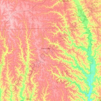
Name: Putnam County topographic map, elevation, terrain.
Location: Putnam County, Missouri, United States (40.34238 -93.38259 40.58957 -92.66434)
Average elevation: 293 m
Minimum elevation: 229 m
Maximum elevation: 339 m
Make a donation
Gear up for your next adventure:
As an Amazon Associate, this site earns from qualifying purchases at no extra cost to you.
Other topographic maps
Click on a map to view its topography, its elevation and its terrain.
Make a donation
Gear up for your next adventure:
As an Amazon Associate, this site earns from qualifying purchases at no extra cost to you.
Mount Vernon
United States > Missouri > Lawrence County > Mount Vernon > Mount Vernon
Average elevation: 379 m
Make a donation
Gear up for your next adventure:
As an Amazon Associate, this site earns from qualifying purchases at no extra cost to you.
Summers Addition
United States > Missouri > Howell County > West Plains > Summers Addition
Average elevation: 306 m