
Thank you for supporting this site ❤️
Make a donation
Make a donation
Gear up for your next adventure:
As an Amazon Associate, this site earns from qualifying purchases at no extra cost to you.
Samseong-dong topographic map
Click on the map to display elevation.
Thank you for supporting this site ❤️
Make a donation
Make a donation
Gear up for your next adventure:
As an Amazon Associate, this site earns from qualifying purchases at no extra cost to you.
About this map
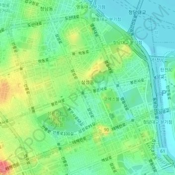
Name: Samseong-dong topographic map, elevation, terrain.
Location: Samseong-dong, Gangnam-gu, Seoul, South Korea (37.50444 127.04131 37.52335 127.06887)
Average elevation: 35 m
Minimum elevation: 4 m
Maximum elevation: 98 m
Thank you for supporting this site ❤️
Make a donation
Make a donation
Gear up for your next adventure:
As an Amazon Associate, this site earns from qualifying purchases at no extra cost to you.