
Mek’ele topographic map
Interactive map
Click on the map to display elevation.
About this map
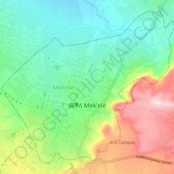
Name: Mek’ele topographic map, elevation, terrain.
Location: Mek’ele, Tigray, Äthiopien (13.47492 39.44380 13.53166 39.51051)
Average elevation: 2,090 m
Minimum elevation: 1,969 m
Maximum elevation: 2,330 m
Other topographic maps
Click on a map to view its topography, its elevation and its terrain.
Haddush Addi
Äthiopien > Tigray > May Ch'iwara > Haddush Addi
Haddush Addi, May Ch'iwara, Central Tigray, Tigray, Äthiopien
Average elevation: 2,593 m
Beati Akor
Äthiopien > Tigray > Beati Akor
Beati Akor, Eastern Tigray, Tigray, 251, Äthiopien
Average elevation: 2,109 m