
Lamerden topographic map
Interactive map
Click on the map to display elevation.
About this map
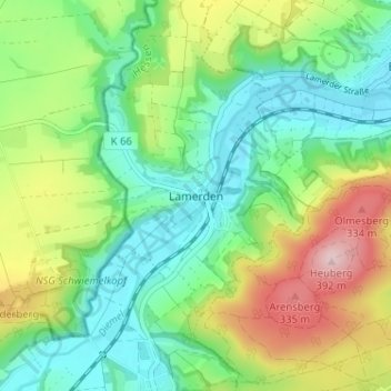
Name: Lamerden topographic map, elevation, terrain.
Location: Lamerden, Liebenau, Landkreis Kassel, Hessen, Deutschland (51.50674 9.30622 51.54674 9.34622)
Average elevation: 215 m
Minimum elevation: 128 m
Maximum elevation: 382 m
Other topographic maps
Click on a map to view its topography, its elevation and its terrain.
FFH-Gebiet Kalkmagerrasen
Deutschland > Hessen > Landkreis Kassel > Lamerden
FFH-Gebiet Kalkmagerrasen, K 66, Steinmühle, Lamerden, Liebenau, Landkreis Kassel, Hessen, 34396, Deutschland
Average elevation: 199 m