Geolocate

Cayey topographic map

Click on the map to display elevation.

About this map
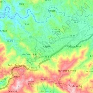
Name: Cayey topographic map, elevation, terrain.

Location: Cayey, Puerto Rico, 00737, United States (18.07275 -66.20634 18.15275 -66.12634)

Average elevation: 489 m

Minimum elevation: 284 m

Maximum elevation: 840 m

Other topographic maps

Click on a map to view its topography, its elevation and its terrain.

Guavate

United States > Puerto Rico > Cayey

Average elevation: 557 m

Jájome Alto

United States > Puerto Rico > Cayey

Average elevation: 579 m

Guavate

United States > Puerto Rico > Cayey

Average elevation: 557 m

Gear up for your next adventure:

☀️Portable Solar Chargers - High-efficiency panels to hang on your backpack while walking
👖Convertible Hiking Trousers - Zip-off legs to adapt to changing temperatures throughout the day
🧥Packable Rain Jackets - Breathable waterproof layers for unpredictable mountain weather
🚴Bike GPS - GPS devices for cycling
📟Satellite Messengers - Two-way satellite communication to stay in touch beyond the cellular grid

As an Amazon Associate, this site earns from qualifying purchases at no extra cost to you.