Geolocate

Norfolk topographic map

Click on the map to display elevation.

About this map

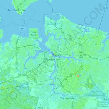
Name: Norfolk topographic map, elevation, terrain.

Location: Norfolk, Virginia, 23510, United States (36.68629 -76.45293 37.00629 -76.13293)

Average elevation: 4 m

Minimum elevation: -7 m

Maximum elevation: 42 m

Other topographic maps

Click on a map to view its topography, its elevation and its terrain.

Lake Taylor

United States > Virginia > Norfolk > Lake Terrace

Average elevation: 7 m

Broad Creek

United States > Virginia > Norfolk > River Oaks

Average elevation: 6 m

Gear up for your next adventure:

🥾Heavy Duty Hiking Boots - Ankle-supporting boots for carrying heavy packs on steep contours
📡Portable Emergency Radios - Stay informed about weather warnings and bushfire alerts
🥾Hiking Gaiters - Leg protection for trails
📱Tablet Tripod Mounts - Steady platforms for viewing digital maps or taking long exposures
🕶️Polarized Outdoor Sunglasses - Reduce glare from rocks and water for better visual navigation

As an Amazon Associate, this site earns from qualifying purchases at no extra cost to you.