
Make a donation
Gear up for your next adventure:
As an Amazon Associate, this site earns from qualifying purchases at no extra cost to you.
Ranfurly topographic map
Click on the map to display elevation.
Make a donation
Gear up for your next adventure:
As an Amazon Associate, this site earns from qualifying purchases at no extra cost to you.
Ranfurly
Ranfurly is a town in the Central Otago District of Otago, New Zealand. Located 110 kilometres (68 miles) north of Dunedin, it lies in the dry rough plain of Maniototo at a moderately high altitude (around 430 metres or 1,410 feet above sea level) close to a small tributary of the Taieri River. It operates as a service town for the local farming community. The town was formerly known as Eweburn, one of the "farmyard" names bestowed by former Otago Chief Surveyor John Turnbull Thomson on many small streams and locations in the district. The modern name honours the Fifth Earl of Ranfurly, who served as Governor of New Zealand (1897–1904) at the time of the extension of the Otago Central Railway to the area. Ranfurly is well known for its Art Deco buildings, such as its hotel and the milk bar.
Make a donation
Gear up for your next adventure:
As an Amazon Associate, this site earns from qualifying purchases at no extra cost to you.
About this map
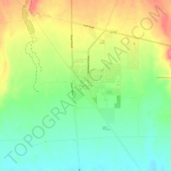
Name: Ranfurly topographic map, elevation, terrain.
Location: Ranfurly, Central Otago District, Otago, 9332, New Zealand (-45.14953 170.07978 -45.10953 170.11978)
Average elevation: 429 m
Minimum elevation: 397 m
Maximum elevation: 472 m
Make a donation
Gear up for your next adventure:
As an Amazon Associate, this site earns from qualifying purchases at no extra cost to you.
Other topographic maps
Click on a map to view its topography, its elevation and its terrain.