
Make a donation
Gear up for your next adventure:
As an Amazon Associate, this site earns from qualifying purchases at no extra cost to you.
Cromwell Community topographic map
Click on the map to display elevation.
Make a donation
Gear up for your next adventure:
As an Amazon Associate, this site earns from qualifying purchases at no extra cost to you.
About this map
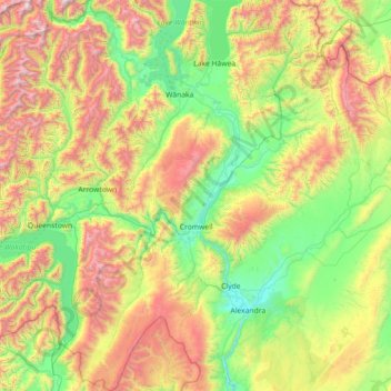
Name: Cromwell Community topographic map, elevation, terrain.
Average elevation: 876 m
Minimum elevation: 133 m
Maximum elevation: 2,593 m
Make a donation
Gear up for your next adventure:
As an Amazon Associate, this site earns from qualifying purchases at no extra cost to you.
Other topographic maps
Click on a map to view its topography, its elevation and its terrain.
Kawarau Gorge
New Zealand > Otago > Central Otago District > Cromwell Community
Average elevation: 339 m
Ranfurly
New Zealand > Otago > Central Otago District
Ranfurly is a town in the Central Otago District of Otago, New Zealand. Located 110 kilometres (68 miles) north of Dunedin, it lies in the dry rough plain of Maniototo at a moderately high altitude (around 430 metres or 1,410 feet above sea level) close to a small tributary of the Taieri River. It operates as…
Average elevation: 429 m
Maniototo Plain
New Zealand > Otago > Central Otago District > Maniototo Community
Average elevation: 409 m