
Rozendaal topographic map
Interactive map
Click on the map to display elevation.
About this map
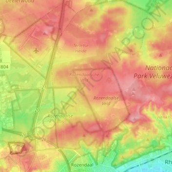
Name: Rozendaal topographic map, elevation, terrain.
Location: Rozendaal, Gelderland, Nederland (51.99964 5.93710 52.07916 6.00899)
Average elevation: 66 m
Minimum elevation: 9 m
Maximum elevation: 106 m
Other topographic maps
Click on a map to view its topography, its elevation and its terrain.
Imbosch
Nederland > Gelderland > Rozendaal
Imbosch, Rozendaal, Gelderland, Nederland, 6891 DZ, Nederland
Average elevation: 71 m
Kasteel Rosendael
Nederland > Gelderland > Rozendaal
Kasteel Rosendael, 1, Rosendael, Rozendaal, Gelderland, Nederland, 6891DA, Nederland
Average elevation: 55 m
Imbosch
Nederland > Gelderland > Rozendaal
Imbosch, Rozendaal, Gelderland, Nederland, 6961 LJ, Nederland
Average elevation: 64 m