
Skonseng topographic map
Interactive map
Click on the map to display elevation.
About this map
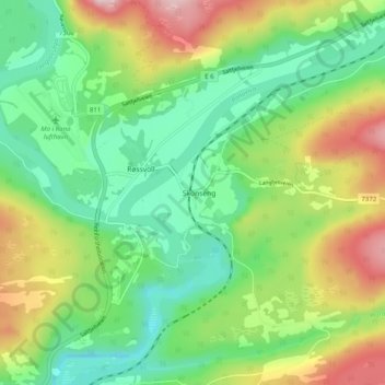
Name: Skonseng topographic map, elevation, terrain.
Location: Skonseng, Rana, Nordland, 8615, Norvège (66.33607 14.31986 66.37607 14.35986)
Average elevation: 104 m
Minimum elevation: 7 m
Maximum elevation: 273 m
Other topographic maps
Click on a map to view its topography, its elevation and its terrain.
Røssnesvågen
Røssnesvågen, Sørland, Værøy, Nordland, 8063, Norvège
Average elevation: 3 m
Stuorgiedde - Storjorda
Stuorgiedde - Storjorda, Hamarøy, Nordland, 8275, Norvège
Average elevation: 42 m
Melnes
Norvège > Nordland > Misvær - Miedasværrda
Melnes, Misvær - Miedasværrda, Bodø, Nordland, 8108, Norvège
Average elevation: 102 m
Festvågen
Norvège > Nordland > Henningsvær > Festvåg
Festvågen, Festvåg, Henningsvær, Vågan, Nordland, Norvège
Average elevation: 61 m
Bognássje - Bognes
Bognássje - Bognes, Hamarøy, Nordland, 8275, Norvège
Average elevation: 50 m