
Moskenes topographic map
Interactive map
Click on the map to display elevation.
About this map
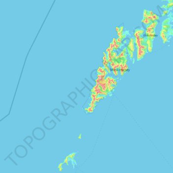
Name: Moskenes topographic map, elevation, terrain.
Location: Moskenes, Nordland, Norvège (67.67407 12.16660 68.15245 13.69498)
Average elevation: 18 m
Minimum elevation: -1 m
Maximum elevation: 1,002 m
Other topographic maps
Click on a map to view its topography, its elevation and its terrain.
Røssnesvågen
Røssnesvågen, Sørland, Værøy, Nordland, 8063, Norvège
Average elevation: 3 m
Stuorgiedde - Storjorda
Stuorgiedde - Storjorda, Hamarøy, Nordland, 8275, Norvège
Average elevation: 42 m
Melnes
Norvège > Nordland > Misvær - Miedasværrda
Melnes, Misvær - Miedasværrda, Bodø, Nordland, 8108, Norvège
Average elevation: 102 m
Festvågen
Norvège > Nordland > Henningsvær > Festvåg
Festvågen, Festvåg, Henningsvær, Vågan, Nordland, Norvège
Average elevation: 61 m
Bognássje - Bognes
Bognássje - Bognes, Hamarøy, Nordland, 8275, Norvège
Average elevation: 50 m