
Cypress topographic map
Interactive map
Click on the map to display elevation.
About this map
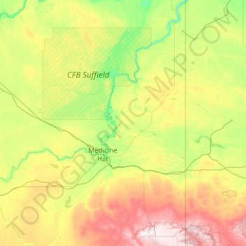
Name: Cypress topographic map, elevation, terrain.
Location: Cypress, Alberta, Canadá (49.56173 -111.15502 50.84173 -109.87502)
Average elevation: 811 m
Minimum elevation: 585 m
Maximum elevation: 1,467 m
Other topographic maps
Click on a map to view its topography, its elevation and its terrain.
Lake Louise
Canadá > Alberta > Division No. 15
Lake Louise, Division No. 15, Alberta, Canadá
Average elevation: 1,617 m
High Prairie
Canadá > Alberta > High Prairie
High Prairie, Town of High Prairie, Alberta, Canadá
Average elevation: 594 m
North Saskatchewan River
North Saskatchewan River, County of Two Hills, Alberta, T5N 1J9, Canadá
Average elevation: 833 m