
Woodlands County topographic map
Interactive map
Click on the map to display elevation.
About this map
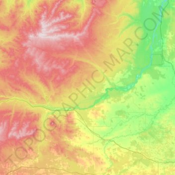
Name: Woodlands County topographic map, elevation, terrain.
Location: Woodlands County, Alberta, Canadá (53.80293 -116.70229 54.85047 -114.22462)
Average elevation: 822 m
Minimum elevation: 558 m
Maximum elevation: 1,385 m
Other topographic maps
Click on a map to view its topography, its elevation and its terrain.
Lake Louise
Canadá > Alberta > Division No. 15
Lake Louise, Division No. 15, Alberta, Canadá
Average elevation: 1,617 m
High Prairie
Canadá > Alberta > High Prairie
High Prairie, Town of High Prairie, Alberta, Canadá
Average elevation: 594 m
North Saskatchewan River
North Saskatchewan River, County of Two Hills, Alberta, T5N 1J9, Canadá
Average elevation: 833 m