
Llyn Fanod topographic map
Interactive map
Click on the map to display elevation.
About this map
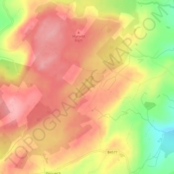
Name: Llyn Fanod topographic map, elevation, terrain.
Location: Llyn Fanod, Llangeitho, Ceredigion, Wales, United Kingdom (52.25749 -4.05101 52.26088 -4.04600)
Average elevation: 300 m
Minimum elevation: 221 m
Maximum elevation: 344 m
Other topographic maps
Click on a map to view its topography, its elevation and its terrain.
Cardigan
United Kingdom > Wales > Ceredigion
Cardigan, Ceredigion, Wales, SA43 1JR, United Kingdom
Average elevation: 81 m
Cefn Coed
United Kingdom > Wales > Ceredigion
Cefn Coed, Ceredigion, Wales, SA44 6NW, United Kingdom
Average elevation: 116 m
Beulah
United Kingdom > Wales > Ceredigion > Beulah
Beulah, Ceredigion, Wales, SA38 9QB, United Kingdom
Average elevation: 139 m
Llanddewi Brefi
United Kingdom > Wales > Ceredigion > Llanddewi Brefi
Llanddewi Brefi, Ceredigion, Wales, SY25 6RS, United Kingdom
Average elevation: 241 m