Geolocate

Jasper topographic map

Click on the map to display elevation.

About this map

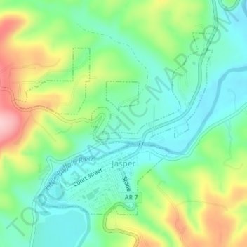
Name: Jasper topographic map, elevation, terrain.

Location: Jasper, Newton County, Arkansas, United States (36.00242 -93.20144 36.02235 -93.17431)

Average elevation: 306 m

Minimum elevation: 241 m

Maximum elevation: 431 m

Other topographic maps

Click on a map to view its topography, its elevation and its terrain.

Sam's Throne

United States > Arkansas > Newton County

Average elevation: 442 m

Deer

United States > Arkansas > Newton County

Average elevation: 639 m

Ben Hur

United States > Arkansas > Newton County

Average elevation: 501 m

Wayton

United States > Arkansas > Newton County

Average elevation: 561 m

Whitaker Point

United States > Arkansas > Newton County

Average elevation: 571 m

Deer

United States > Arkansas > Newton County

Average elevation: 639 m

Glory Hole

United States > Arkansas > Newton County

Average elevation: 590 m

Ryker

United States > Arkansas > Newton County

Average elevation: 641 m

North Pole Knob

United States > Arkansas > Newton County

Average elevation: 412 m

Hasty

United States > Arkansas > Newton County

Average elevation: 337 m

Bass

United States > Arkansas > Newton County

Average elevation: 322 m

Erbie

United States > Arkansas > Newton County

Average elevation: 361 m

Ponca

United States > Arkansas > Newton County

Average elevation: 443 m

Marble Falls

United States > Arkansas > Newton County

Average elevation: 349 m

Compton

United States > Arkansas > Newton County

Average elevation: 635 m

Pruitt

United States > Arkansas > Newton County

Average elevation: 300 m

Ponca

United States > Arkansas > Newton County

Average elevation: 443 m

Compton

United States > Arkansas > Newton County

Average elevation: 635 m

Gear up for your next adventure:

🍳Camping Cookware - Cookware sets for outdoor meals
🛰️Handheld GPS Units - Rugged GPS devices for tracking coordinates and elevation in the Australian bush
🧺Fast-Dry Microfiber Towels - Large towels that pack down to the size of an orange
📡Satellite Messengers - Emergency communication devices
📚Map Reading & Navigation Guides - Master the art of interpreting topographic contours and symbols

As an Amazon Associate, this site earns from qualifying purchases at no extra cost to you.