
Compton topographic map
Click on the map to display elevation.
About this map
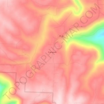
Name: Compton topographic map, elevation, terrain.
Location: Compton, Newton County, Arkansas, 72624, United States (36.07674 -93.32268 36.11674 -93.28268)
Average elevation: 635 m
Minimum elevation: 407 m
Maximum elevation: 704 m
Other topographic maps
Click on a map to view its topography, its elevation and its terrain.
Buffalo National River
United States > Arkansas > Newton County
Along the upper river, the gradient is steep and the water is fast, leveling and slowing as the river runs its course. The upper section has most of the whitewater rapids to be found along the river, and features dramatic karst topography including sink holes and caves, springs, and waterfalls, over 500-foot…
Average elevation: 444 m