Geolocate

Mudgeeraba topographic map

Click on the map to display elevation.

About this map

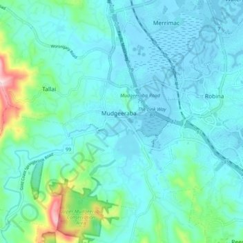
Name: Mudgeeraba topographic map, elevation, terrain.

Location: Mudgeeraba, Gold Coast, Queensland, Australia (-28.11686 153.30765 -28.04949 153.39318)

Average elevation: 50 m

Minimum elevation: -3 m

Maximum elevation: 331 m

Queensland trails, hiking, mountain biking, running and outdoor activities

Other topographic maps

Click on a map to view its topography, its elevation and its terrain.

Pimpama

Australia > Queensland > Gold Coast > Pimpama

Average elevation: 19 m

Maudsland

Australia > Queensland > Gold Coast

Average elevation: 43 m

Reedy Creek

Australia > Queensland > Gold Coast

Average elevation: 16 m

Lower Beechmont

Australia > Queensland > Gold Coast

Average elevation: 297 m

Clagiraba

Australia > Queensland > Gold Coast

Average elevation: 122 m

Binna Burra

Australia > Queensland > Gold Coast

Average elevation: 535 m

Guanaba

Australia > Queensland > Gold Coast

Average elevation: 51 m

Gear up for your next adventure:

🔥Windproof Plasma Lighters - USB rechargeable lighters that work in high-altitude winds
🎨Portable Watercolor Kits - Paint the landscapes and topographic views you discover
🎒Hiking Backpacks - Backpacks designed for hiking and trekking
📱Shockproof Phone Cases - Extra protection for your smartphone against drops on rocky terrain
🥾Hiking Boots - Durable hiking boots for trails and rough terrain

As an Amazon Associate, this site earns from qualifying purchases at no extra cost to you.