
Chiriquí topographic map
Interactive map
Click on the map to display elevation.
About this map
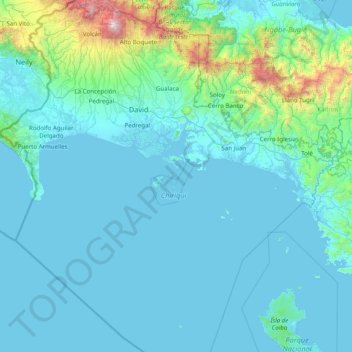
Name: Chiriquí topographic map, elevation, terrain.
Location: Chiriquí, Panama (7.35761 -83.05172 8.92228 -81.51150)
Average elevation: 250 m
Minimum elevation: -1 m
Maximum elevation: 3,416 m
Other topographic maps
Click on a map to view its topography, its elevation and its terrain.
San Andres
Panama > Chiriquí > Distrito Bugaba
San Andres, Distrito Bugaba, Chiriquí, Panama
Average elevation: 686 m
Volcán
Panama > Chiriquí > Distrito Tierras Altas
Volcán, Distrito Tierras Altas, Chiriquí, Panama
Average elevation: 1,165 m