
Make a donation
Gear up for your next adventure:
As an Amazon Associate, this site earns from qualifying purchases at no extra cost to you.
Petting topographic map
Click on the map to display elevation.
Make a donation
Gear up for your next adventure:
As an Amazon Associate, this site earns from qualifying purchases at no extra cost to you.
About this map
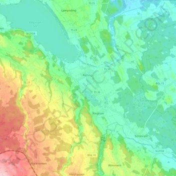
Name: Petting topographic map, elevation, terrain.
Location: Petting, Landkreis Traunstein, Bayern, 83367, Deutschland (47.87671 12.76742 47.93849 12.88673)
Average elevation: 480 m
Minimum elevation: 419 m
Maximum elevation: 611 m
Make a donation
Gear up for your next adventure:
As an Amazon Associate, this site earns from qualifying purchases at no extra cost to you.
Other topographic maps
Click on a map to view its topography, its elevation and its terrain.
Waginger See
Deutschland > Bayern > Landkreis Traunstein > Waging am See > Fisching
Der See friert auch heute noch in strengen Wintern zu. Bis in die 1960er Jahre war das fast alljährlich der Fall. Der Waginger See friert wegen der höheren Durchschnittstemperatur und wohl auch wegen größerer Strömungen einige Tage später zu als der Tachinger See. Nur bei lang andauernden und extrem…
Average elevation: 464 m
Rauschberg
Deutschland > Bayern > Landkreis Traunstein > Ruhpolding
Der Rauschberg ist ein mehrgipfeliger Gebirgsstock in den Chiemgauer Alpen mit einer maximalen Höhe von 1671 m ü. NHN.
Average elevation: 1,115 m
Make a donation
Gear up for your next adventure:
As an Amazon Associate, this site earns from qualifying purchases at no extra cost to you.
Make a donation
Gear up for your next adventure:
As an Amazon Associate, this site earns from qualifying purchases at no extra cost to you.
Make a donation
Gear up for your next adventure:
As an Amazon Associate, this site earns from qualifying purchases at no extra cost to you.
Make a donation
Gear up for your next adventure:
As an Amazon Associate, this site earns from qualifying purchases at no extra cost to you.
Seegatterl
Deutschland > Bayern > Landkreis Traunstein > Reit im Winkl > Seegatterl
Average elevation: 1,031 m
Make a donation
Gear up for your next adventure:
As an Amazon Associate, this site earns from qualifying purchases at no extra cost to you.
Make a donation
Gear up for your next adventure:
As an Amazon Associate, this site earns from qualifying purchases at no extra cost to you.
Make a donation
Gear up for your next adventure:
As an Amazon Associate, this site earns from qualifying purchases at no extra cost to you.
Make a donation
Gear up for your next adventure:
As an Amazon Associate, this site earns from qualifying purchases at no extra cost to you.
Make a donation
Gear up for your next adventure:
As an Amazon Associate, this site earns from qualifying purchases at no extra cost to you.
Make a donation
Gear up for your next adventure:
As an Amazon Associate, this site earns from qualifying purchases at no extra cost to you.
Make a donation
Gear up for your next adventure:
As an Amazon Associate, this site earns from qualifying purchases at no extra cost to you.
Make a donation
Gear up for your next adventure:
As an Amazon Associate, this site earns from qualifying purchases at no extra cost to you.
Make a donation
Gear up for your next adventure:
As an Amazon Associate, this site earns from qualifying purchases at no extra cost to you.
Make a donation
Gear up for your next adventure:
As an Amazon Associate, this site earns from qualifying purchases at no extra cost to you.
Oberhaus
Deutschland > Bayern > Landkreis Traunstein > Traunreut > Stein an der Traun
Average elevation: 530 m
Make a donation
Gear up for your next adventure:
As an Amazon Associate, this site earns from qualifying purchases at no extra cost to you.
Make a donation
Gear up for your next adventure:
As an Amazon Associate, this site earns from qualifying purchases at no extra cost to you.
Make a donation
Gear up for your next adventure:
As an Amazon Associate, this site earns from qualifying purchases at no extra cost to you.
Make a donation
Gear up for your next adventure:
As an Amazon Associate, this site earns from qualifying purchases at no extra cost to you.
Hinterwies
Deutschland > Bayern > Landkreis Traunstein > Traunreut > St. Georgen
Average elevation: 545 m
Traunwalchen
Deutschland > Bayern > Landkreis Traunstein > Traunreut
Traunwalchen liegt an der Traun, einem Nebenfluss der Alz, auf einer Höhe von 556 m ü. NN. Der Ort teilt sich in ein Ober- und Unterdorf sowie die nach 1945 entstandene Siedlung. Neue Baugebiete um die Jahrtausendwende sind die Zachersdorfer Äcker und Frauenbrunn.
Average elevation: 560 m
Make a donation
Gear up for your next adventure:
As an Amazon Associate, this site earns from qualifying purchases at no extra cost to you.
Holzleiten
Deutschland > Bayern > Landkreis Traunstein > Waging am See > Fisching
Average elevation: 498 m
Make a donation
Gear up for your next adventure:
As an Amazon Associate, this site earns from qualifying purchases at no extra cost to you.
Make a donation
Gear up for your next adventure:
As an Amazon Associate, this site earns from qualifying purchases at no extra cost to you.
Sternenpark Winklmoos-Alm
Deutschland > Bayern > Landkreis Traunstein > Reit im Winkl > Winklmoosalm
Average elevation: 1,174 m
Make a donation
Gear up for your next adventure:
As an Amazon Associate, this site earns from qualifying purchases at no extra cost to you.
Haslach
Deutschland > Bayern > Landkreis Traunstein > Traunstein
Das Pfarrdorf Haslach liegt etwa 1,7 km südwestlich vom Traunsteiner Stadtzentrum, etwa 8 km östlich des Chiemsees und 15 km nördlich der Chiemgauer Alpen auf einer Höhe von 610 m ü. NN.
Average elevation: 616 m
Make a donation
Gear up for your next adventure:
As an Amazon Associate, this site earns from qualifying purchases at no extra cost to you.
Make a donation
Gear up for your next adventure:
As an Amazon Associate, this site earns from qualifying purchases at no extra cost to you.
Hochgern
Deutschland > Bayern > Landkreis Traunstein > Unterwössen
Der Hochgern bildet einen markanten Bergstock innerhalb der Bayerischen Alpen, der sich südlich über dem Chiemsee erhebt. Mit einer Schartenhöhe von 967 Metern gehört der Gipfel zu den eigenständigsten der Chiemgauer Alpen. Um seinen zentral gelegenen Gipfel scharen sich mehrere etwas niedrigere Berge, so…
Average elevation: 1,291 m
Make a donation
Gear up for your next adventure:
As an Amazon Associate, this site earns from qualifying purchases at no extra cost to you.