Geolocate
👉 Easily get elevation data in JSON, GeoTIFF and KML formats using Elevation API
Thank you for supporting this site ❤️
Make a donation

Gear up for your next adventure:

As an Amazon Associate, this site earns from qualifying purchases at no extra cost to you.

Oberlin topographic map

Click on the map to display elevation.

About this map

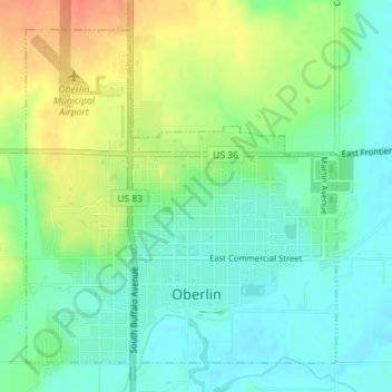
Name: Oberlin topographic map, elevation, terrain.

Location: Oberlin, Decatur County, Kansas, 67749, United States (39.81351 -100.54368 39.83675 -100.50821)

Average elevation: 794 m

Minimum elevation: 774 m

Maximum elevation: 827 m

Other topographic maps

Click on a map to view its topography, its elevation and its terrain.

Cedar Bluffs

United States > Kansas > Decatur County

Average elevation: 794 m

Leoville

United States > Kansas > Decatur County

Average elevation: 842 m

Gear up for your next adventure:

🧭Military Style Lensatic Compass - Durable sighting compasses for advanced land navigation and surveying
🥶Thermal Beanies - Warm hats for cold hikes
🛰️Handheld GPS Units - Rugged GPS devices for tracking coordinates and elevation in the Australian bush
👟Lightweight Trail Runners - Agile footwear for fast movement over rugged Australian terrain
🍶Collapsible Water Bottles - Save space in your pack as you consume your water supply

As an Amazon Associate, this site earns from qualifying purchases at no extra cost to you.