Geolocate

Cedar Bluffs topographic map

Click on the map to display elevation.

About this map

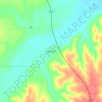
Name: Cedar Bluffs topographic map, elevation, terrain.

Location: Cedar Bluffs, Decatur County, Kansas, United States (39.95889 -100.58181 39.99889 -100.54181)

Average elevation: 794 m

Minimum elevation: 768 m

Maximum elevation: 835 m

Other topographic maps

Click on a map to view its topography, its elevation and its terrain.

Oberlin

United States > Kansas > Decatur County

Average elevation: 794 m

Jennings

United States > Kansas > Decatur County

Average elevation: 769 m

Dresden

United States > Kansas > Decatur County

Average elevation: 828 m

Gear up for your next adventure:

📱Tablet Tripod Mounts - Steady platforms for viewing digital maps or taking long exposures
🛌Sleeping Mats - Insulated mats for camping comfort
📕Australia Maps - Maps covering Australian regions
🎒Hiking Backpacks - Backpacks designed for hiking and trekking
🔌Fast Charging Adapters - Quickly top up all your gear before heading back into the field

As an Amazon Associate, this site earns from qualifying purchases at no extra cost to you.