
Singhbhūm topographic map
Interactive map
Click on the map to display elevation.
About this map
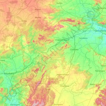
Name: Singhbhūm topographic map, elevation, terrain.
Location: Singhbhūm, Pashchimi Singhbhum, Jharkhand, Indien (21.86000 84.86000 23.14000 86.14000)
Average elevation: 373 m
Minimum elevation: 124 m
Maximum elevation: 928 m
Other topographic maps
Click on a map to view its topography, its elevation and its terrain.
Jamshedpur
Indien > Jharkhand > Golmuri-Cum-Jugsalai
Jamshedpur, Golmuri-Cum-Jugsalai, Purbi Singhbhum, Jharkhand, 831001, Indien
Average elevation: 195 m