Geolocate

Rahe topographic map

Interactive map

Click on the map to display elevation.

About this map

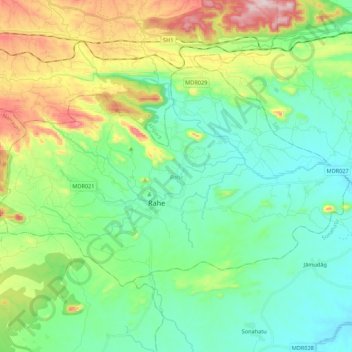
Name: Rahe topographic map, elevation, terrain.

Location: Rahe, Ranchi, Jharkhand, Indien (23.22096 85.54710 23.34525 85.76391)

Average elevation: 351 m

Minimum elevation: 228 m

Maximum elevation: 661 m

Other topographic maps

Click on a map to view its topography, its elevation and its terrain.

Ramgarh

Indien > Jharkhand

Ramgarh, Dumka District, Jharkhand, Indien

Average elevation: 198 m

Basgo

Indien > Jharkhand > Barhait

Basgo, Barhait, Sahibganj District, Jharkhand, Indien

Average elevation: 169 m

Ranchi

Indien > Jharkhand > Kanke

Ranchi, Kanke, Ranchi District, Jharkhand, 834001, Indien

Average elevation: 648 m

Angara

Indien > Jharkhand > Angara

Angara, Ranchi, Jharkhand, 835104, Indien

Average elevation: 562 m

Singhbhūm

Indien > Jharkhand

Singhbhūm, Pashchimi Singhbhum, Jharkhand, Indien

Average elevation: 373 m

Jamshedpur

Indien > Jharkhand > Golmuri-Cum-Jugsalai

Jamshedpur, Golmuri-Cum-Jugsalai, Purbi Singhbhum, Jharkhand, 831001, Indien

Average elevation: 195 m