
Page County topographic map
Interactive map
Click on the map to display elevation.
About this map
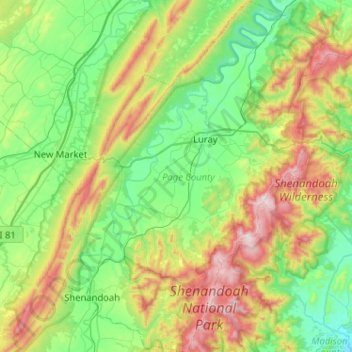
Name: Page County topographic map, elevation, terrain.
Location: Page County, Virginia, Verenigde Staten (38.42158 -78.69136 38.82279 -78.28480)
Average elevation: 444 m
Minimum elevation: 127 m
Maximum elevation: 1,216 m
Other topographic maps
Click on a map to view its topography, its elevation and its terrain.
Leemaster
Verenigde Staten > Virginia > Buchanan County
Leemaster, Buchanan County, Virginia, 24656, Verenigde Staten
Average elevation: 598 m
Culpeper
Verenigde Staten > Virginia > Culpeper County > Culpeper
Culpeper, Culpeper County, Virginia, 22701, Verenigde Staten
Average elevation: 129 m
Hampton
Verenigde Staten > Virginia > Hampton
Hampton, Virginia, 23669-4019, Verenigde Staten
Average elevation: 3 m
Lurich
Verenigde Staten > Virginia > Lurich
Lurich, Giles County, Virginia, 24093, Verenigde Staten
Average elevation: 535 m
Shenandoah County
Shenandoah County, Virginia, Verenigde Staten
Average elevation: 433 m