
Flag topographic map
Interactive map
Click on the map to display elevation.
About this map
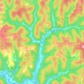
Name: Flag topographic map, elevation, terrain.
Location: Flag, Noble County, Ohio, 43786, United States (39.66646 -81.32484 39.70646 -81.28484)
Average elevation: 278 m
Minimum elevation: 206 m
Maximum elevation: 352 m
Other topographic maps
Click on a map to view its topography, its elevation and its terrain.
Caldwell
United States > Ohio > Noble County
Caldwell, Noble County, Ohio, United States
Average elevation: 247 m
Batesville
United States > Ohio > Noble County
Batesville, Noble County, Ohio, United States
Average elevation: 308 m
Belle Valley
United States > Ohio > Noble County > Belle Valley
Belle Valley, Noble County, Ohio, 43717, United States
Average elevation: 251 m
Mount Zion
United States > Ohio > Noble County > Mount Zion
Mount Zion, Noble County, Ohio, 43772, United States
Average elevation: 274 m