
Kiryowa topographic map
Interactive map
Click on the map to display elevation.
About this map
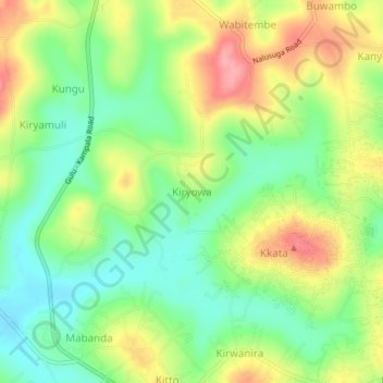
Name: Kiryowa topographic map, elevation, terrain.
Location: Kiryowa, Wakiso, Central Region, Uganda (0.46333 32.51333 0.50333 32.55333)
Average elevation: 1,188 m
Minimum elevation: 1,142 m
Maximum elevation: 1,249 m
Other topographic maps
Click on a map to view its topography, its elevation and its terrain.
Kireku Railway
Kireku Railway, Wakiso, Central Region, Uganda
Average elevation: 1,161 m
Lyamutundwe
Uganda > Wakiso > Lyamutundwe
Lyamutundwe, Wakiso, Central Region, P.O. BOX 182 - ENTEBBE, Uganda
Average elevation: 1,155 m