
Entebbe City topographic map
Interactive map
Click on the map to display elevation.
About this map
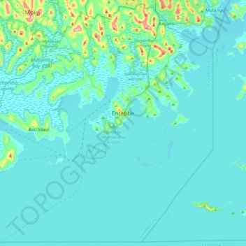
Name: Entebbe City topographic map, elevation, terrain.
Location: Entebbe City, Wakiso, Central Region, Uganda (-0.15304 32.21198 0.24197 32.61936)
Average elevation: 1,146 m
Minimum elevation: 1,129 m
Maximum elevation: 1,328 m
Entebbe experiences tropical rainforest climate (Af) according to the Köppen climate classification as the city has no real dry season throughout the year. The driest season is January with precipitation total 65 millimetres (2.6 in), while the wettest season is April with precipitation total 256 millimetres (10.1 in). The temperature is moderated by the altitude. The hottest month is February with average temperature 22.8 °C (73.0 °F), while the coolest month is July with average temperature 20.6 °C (69.1 °F).
Other topographic maps
Click on a map to view its topography, its elevation and its terrain.
Water
Uganda > Wakiso > Entebbe City
Water, Entebbe City, Wakiso, Central Region, Uganda
Average elevation: 1,134 m
Old Entebbe Subward Airbase
Uganda > Wakiso > Entebbe City
Old Entebbe Subward Airbase, Kigungu Ward, Entebbe City, Wakiso, Central Region, Uganda
Average elevation: 1,158 m