Geolocate

Barnesville topographic map

Click on the map to display elevation.

About this map

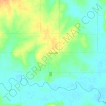
Name: Barnesville topographic map, elevation, terrain.

Location: Barnesville, Bourbon County, Kansas, United States (37.99531 -94.68135 38.03531 -94.64135)

Average elevation: 252 m

Minimum elevation: 239 m

Maximum elevation: 274 m

Other topographic maps

Click on a map to view its topography, its elevation and its terrain.

Mapleton

United States > Kansas > Bourbon County

Average elevation: 267 m

Redfield

United States > Kansas > Bourbon County

Average elevation: 263 m

Fulton

United States > Kansas > Bourbon County

Average elevation: 252 m

Bronson

United States > Kansas > Bourbon County

Average elevation: 323 m

Gear up for your next adventure:

Survival Blankets - Emergency thermal blankets
💡Collapsible Camping Lanterns - Illuminate your base camp or tent for map studying at night
📻Handheld UHF Radios - Critical communication for groups in the Australian outback
🧥Down Jackets - Insulated jackets for cold weather
🎒40L Day Hiking Backpacks - Comfortable packs with hydration support for long days exploring topographic peaks

As an Amazon Associate, this site earns from qualifying purchases at no extra cost to you.