Geolocate

Redfield topographic map

Click on the map to display elevation.

About this map

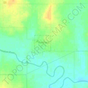
Name: Redfield topographic map, elevation, terrain.

Location: Redfield, Bourbon County, Kansas, United States (37.83366 -94.88455 37.83908 -94.87818)

Average elevation: 263 m

Minimum elevation: 251 m

Maximum elevation: 279 m

Other topographic maps

Click on a map to view its topography, its elevation and its terrain.

Xenia

United States > Kansas > Bourbon County

Average elevation: 295 m

Porterville

United States > Kansas > Bourbon County

Average elevation: 317 m

Pawnee Station

United States > Kansas > Bourbon County

Average elevation: 296 m

Marmaton

United States > Kansas > Bourbon County

Average elevation: 266 m

Hiattville

United States > Kansas > Bourbon County

Average elevation: 293 m

Harding

United States > Kansas > Bourbon County

Average elevation: 267 m

Hammond

United States > Kansas > Bourbon County

Average elevation: 266 m

Godfrey

United States > Kansas > Bourbon County

Average elevation: 287 m

Garland

United States > Kansas > Bourbon County

Average elevation: 259 m

Devon

United States > Kansas > Bourbon County

Average elevation: 268 m

Barnesville

United States > Kansas > Bourbon County

Average elevation: 252 m

Gear up for your next adventure:

Survival Blankets - Emergency thermal blankets
🧦Merino Wool Hiking Socks - Moisture-wicking socks to prevent blisters during long topographic surveys
🧰Survival Kits - Essential survival gear
👣Snake & Scrub Gaiters - Protection against spinifex, mud, and snakes while walking off-track
🔋Solar Power Banks - Charge your phone and GPS using the sun while deep in the bush

As an Amazon Associate, this site earns from qualifying purchases at no extra cost to you.