Geolocate

Devon topographic map

Click on the map to display elevation.

About this map

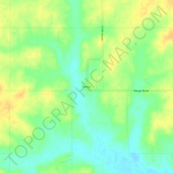
Name: Devon topographic map, elevation, terrain.

Location: Devon, Bourbon County, Kansas, United States (37.90226 -94.83913 37.94226 -94.79913)

Average elevation: 268 m

Minimum elevation: 254 m

Maximum elevation: 282 m

Other topographic maps

Click on a map to view its topography, its elevation and its terrain.

Mapleton

United States > Kansas > Bourbon County

Average elevation: 267 m

Redfield

United States > Kansas > Bourbon County

Average elevation: 263 m

Fulton

United States > Kansas > Bourbon County

Average elevation: 252 m

Bronson

United States > Kansas > Bourbon County

Average elevation: 323 m

Gear up for your next adventure:

🔪Multitools - Compact tools for outdoor use
🌬️Windbreaker Jackets - Wind protection jackets
🛰️Handheld GPS Units - Rugged GPS devices for tracking coordinates and elevation in the Australian bush
🧥Thermal Emergency Blankets - Compact Mylar blankets to prevent hypothermia if stranded overnight
👖Convertible Hiking Trousers - Zip-off legs to adapt to changing temperatures throughout the day

As an Amazon Associate, this site earns from qualifying purchases at no extra cost to you.