Geolocate

Xenia topographic map

Click on the map to display elevation.

About this map

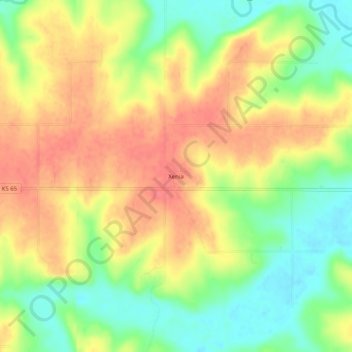
Name: Xenia topographic map, elevation, terrain.

Location: Xenia, Bourbon County, Kansas, United States (37.97531 -95.00636 38.01531 -94.96636)

Average elevation: 295 m

Minimum elevation: 262 m

Maximum elevation: 323 m

Other topographic maps

Click on a map to view its topography, its elevation and its terrain.

Mapleton

United States > Kansas > Bourbon County

Average elevation: 267 m

Redfield

United States > Kansas > Bourbon County

Average elevation: 263 m

Fulton

United States > Kansas > Bourbon County

Average elevation: 252 m

Bronson

United States > Kansas > Bourbon County

Average elevation: 323 m

Gear up for your next adventure:

🪑Portable Backpacking Chairs - A comfortable seat for studying maps at the end of the day
📕Australia Maps - Maps covering Australian regions
📱Shockproof Phone Cases - Extra protection for your smartphone against drops on rocky terrain
🛠️Outdoor Repair Kits - Gear repair kits
🆘Personal Locator Beacons (PLB) - Satellite emergency beacons for life-saving help in areas with no mobile coverage

As an Amazon Associate, this site earns from qualifying purchases at no extra cost to you.