
Catron County topographic map
Interactive map
Click on the map to display elevation.
About this map
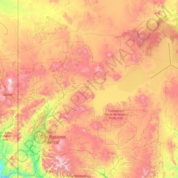
Name: Catron County topographic map, elevation, terrain.
Location: Catron County, New Mexico, United States (33.19898 -109.04747 34.58097 -107.71135)
Average elevation: 2,231 m
Minimum elevation: 1,330 m
Maximum elevation: 3,323 m
Other topographic maps
Click on a map to view its topography, its elevation and its terrain.
Santa Ana Pueblo
United States > New Mexico > Sandoval County
Santa Ana Pueblo, Sandoval County, New Mexico, United States
Average elevation: 1,576 m
San Francisco
United States > New Mexico > Catron County
San Francisco, Catron County, New Mexico, United States
Average elevation: 2,440 m
White Sands
United States > New Mexico > Doña Ana County
White Sands, Doña Ana County, New Mexico, 88002, United States
Average elevation: 1,333 m
Santa Fe
United States > New Mexico > Santa Fe County
Santa Fe, Santa Fe County, New Mexico, United States
Average elevation: 2,221 m
Roswell
United States > New Mexico > Chaves County
Roswell, Chaves County, New Mexico, United States
Average elevation: 1,106 m
Grant County
Grant County, New Mexico, United States
Average elevation: 1,599 m
Riley Black Standpipe, Mount
United States > New Mexico > Doña Ana County
Riley Black Standpipe, Mount, Doña Ana County, New Mexico, United States
Average elevation: 1,254 m
Standing Rock
United States > New Mexico > McKinley County > Standing Rock
Standing Rock, Eastern Navajo Agency, McKinley County, New Mexico, United States
Average elevation: 1,931 m
Chama
United States > New Mexico > Rio Arriba County > Chama
Chama, Rio Arriba County, New Mexico, 87520, United States
Average elevation: 2,430 m
Mount Taylor
United States > New Mexico > Cibola County
Mount Taylor, Cibola County, New Mexico, United States
Average elevation: 3,168 m
Torreon
United States > New Mexico > Sandoval County
Torreon, Eastern Navajo Agency, Sandoval County, New Mexico, United States
Average elevation: 1,984 m
Tinian
United States > New Mexico > McKinley County > Tinian
Tinian, McKinley County, New Mexico, United States
Average elevation: 2,014 m
Rancho Viejo
United States > New Mexico > Rancho Viejo
Rancho Viejo, Santa Fe County, New Mexico, 87507-9720, United States
Average elevation: 1,979 m
Torrance County
Torrance County, New Mexico, United States
Average elevation: 1,983 m
Mora County
Mora County, New Mexico, United States
Average elevation: 2,150 m
Cibola County
Cibola County, New Mexico, United States
Average elevation: 2,124 m
Taos County
Taos County, New Mexico, United States
Average elevation: 2,561 m
Socorro County
Socorro County, New Mexico, United States
Average elevation: 1,830 m
Santa Fe County
Santa Fe County, New Mexico, United States
Average elevation: 2,177 m
Bernalillo County
Bernalillo County, New Mexico, United States
Average elevation: 1,808 m
Lea County
United States > New Mexico > Lea County
Lea County, New Mexico, United States
Average elevation: 1,100 m
Shiprock
United States > New Mexico > San Juan County
Shiprock, Shiprock Agency, San Juan County, New Mexico, 87420, United States
Average elevation: 1,524 m
Angel Fire
United States > New Mexico > Colfax County
Angel Fire, Colfax County, New Mexico, 87710, United States
Average elevation: 2,786 m