
Dalby topographic map
Interactive map
Click on the map to display elevation.
About this map
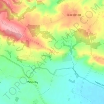
Name: Dalby topographic map, elevation, terrain.
Average elevation: 80 m
Minimum elevation: 32 m
Maximum elevation: 151 m
Other topographic maps
Click on a map to view its topography, its elevation and its terrain.
East Rounton
United Kingdom > England > North Yorkshire > Hambleton
East Rounton, Hambleton, North Yorkshire, England, United Kingdom
Average elevation: 65 m
Carlton in Cleveland
United Kingdom > England > North Yorkshire > Hambleton
Great Busby, Carlton in Cleveland, Hambleton, North Yorkshire, England, United Kingdom
Average elevation: 112 m