
Leuk topographic map
Interactive map
Click on the map to display elevation.
About this map
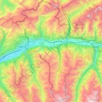
Name: Leuk topographic map, elevation, terrain.
Location: Leuk, Vallés, Suiza (46.11075 7.52860 46.44505 7.76248)
Average elevation: 2,007 m
Minimum elevation: 495 m
Maximum elevation: 4,214 m
Other topographic maps
Click on a map to view its topography, its elevation and its terrain.
Les Marécottes
Suiza > Vallés > Saint-Maurice
Les Marécottes, Salvan, Saint-Maurice, Vallés, 1923, Suiza
Average elevation: 1,354 m