
Make a donation
Gear up for your next adventure:
As an Amazon Associate, this site earns from qualifying purchases at no extra cost to you.
Urubamba topographic map
Click on the map to display elevation.
Make a donation
Gear up for your next adventure:
As an Amazon Associate, this site earns from qualifying purchases at no extra cost to you.
About this map
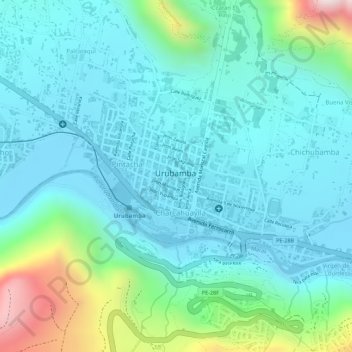
Name: Urubamba topographic map, elevation, terrain.
Location: Urubamba, Province of Urubamba, Cusco, 08661, Peru (-13.31333 -72.12369 -13.29901 -72.10317)
Average elevation: 2,970 m
Minimum elevation: 2,848 m
Maximum elevation: 3,410 m
Make a donation
Gear up for your next adventure:
As an Amazon Associate, this site earns from qualifying purchases at no extra cost to you.
Other topographic maps
Click on a map to view its topography, its elevation and its terrain.
Vinicunca
Vinicunca, or Winikunka, also called Montaña de Siete Colores (literally: Mountain of seven colors), Montaña de Colores (Mountain of colors) or Montaña Arcoíris (Rainbow Mountain), is a mountain in the Andes of Peru with an altitude of 5,200 metres (17,100 ft) above sea level. It is located on the road to…
Average elevation: 4,874 m
Make a donation
Gear up for your next adventure:
As an Amazon Associate, this site earns from qualifying purchases at no extra cost to you.