
Make a donation
Gear up for your next adventure:
As an Amazon Associate, this site earns from qualifying purchases at no extra cost to you.
Acheron topographic map
Click on the map to display elevation.
Make a donation
Gear up for your next adventure:
As an Amazon Associate, this site earns from qualifying purchases at no extra cost to you.
About this map
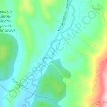
Name: Acheron topographic map, elevation, terrain.
Average elevation: 353 m
Minimum elevation: 271 m
Maximum elevation: 575 m
Make a donation
Gear up for your next adventure:
As an Amazon Associate, this site earns from qualifying purchases at no extra cost to you.
Other topographic maps
Click on a map to view its topography, its elevation and its terrain.
Λόφοι
Greece > Epirus and Western Macedonia > Florina Regional Unit > Meliti Municipal Unit
Average elevation: 710 m
Florina
Greece > Epirus and Western Macedonia > Florina Regional Unit
Florina is one of the coldest towns in Greece, because of its elevation and geographic position. Snowfalls, sometimes heavy, thick fog and below-freezing temperatures are common during the winter months, while the summers are warm to hot. Under the Köppen climate classification, Florina has a humid…
Average elevation: 999 m