
Make a donation
Gear up for your next adventure:
As an Amazon Associate, this site earns from qualifying purchases at no extra cost to you.
Dumfries topographic map
Click on the map to display elevation.
Make a donation
Gear up for your next adventure:
As an Amazon Associate, this site earns from qualifying purchases at no extra cost to you.
About this map
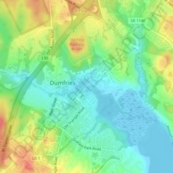
Name: Dumfries topographic map, elevation, terrain.
Location: Dumfries, Prince William County, Virginia, United States (38.55494 -77.33922 38.57893 -77.30120)
Average elevation: 26 m
Minimum elevation: -7 m
Maximum elevation: 67 m
Make a donation
Gear up for your next adventure:
As an Amazon Associate, this site earns from qualifying purchases at no extra cost to you.
Other topographic maps
Click on a map to view its topography, its elevation and its terrain.
Occoquan Bay National Wildlife Refuge
United States > Virginia > Prince William County > Woodbridge
Average elevation: 3 m
Make a donation
Gear up for your next adventure:
As an Amazon Associate, this site earns from qualifying purchases at no extra cost to you.
Chamberlain Village
United States > Virginia > Prince William County > Quantico > Chamberlain Village
Average elevation: 16 m
Bull Run Mountain Estates
United States > Virginia > Prince William County > Bull Run Mountain Estates
Average elevation: 197 m
Silver Lake Regional Park
United States > Virginia > Prince William County > Haymarket
Average elevation: 131 m