
Armel topographic map
Click on the map to display elevation.
About this map
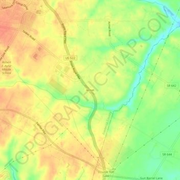
Name: Armel topographic map, elevation, terrain.
Location: Armel, Frederick County, Virginia, 22663, United States (39.05927 -78.16361 39.09927 -78.12361)
Average elevation: 207 m
Minimum elevation: 179 m
Maximum elevation: 225 m
Other topographic maps
Click on a map to view its topography, its elevation and its terrain.
Kernstown Battlefield Park
United States > Virginia > Frederick County > Winchester > Valley Acres
Average elevation: 241 m