
Make a donation
Gear up for your next adventure:
As an Amazon Associate, this site earns from qualifying purchases at no extra cost to you.
Burgundy topographic map
Click on the map to display elevation.
Make a donation
Gear up for your next adventure:
As an Amazon Associate, this site earns from qualifying purchases at no extra cost to you.
About this map
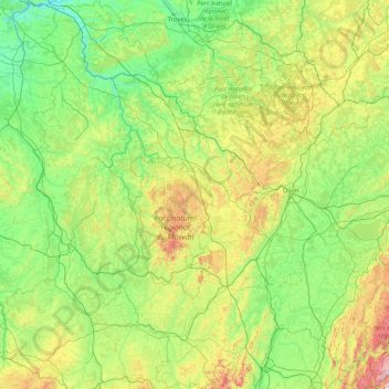
Name: Burgundy topographic map, elevation, terrain.
Location: Burgundy, Metropolitan France, France (46.15601 2.84448 48.40006 5.51887)
Average elevation: 286 m
Minimum elevation: 47 m
Maximum elevation: 1,513 m
Make a donation
Gear up for your next adventure:
As an Amazon Associate, this site earns from qualifying purchases at no extra cost to you.
Other topographic maps
Click on a map to view its topography, its elevation and its terrain.
La Villa Trévi
France > Auvergne-Rhône-Alpes > Upper Savoy > Épagny Metz-Tessy
Average elevation: 493 m
Make a donation
Gear up for your next adventure:
As an Amazon Associate, this site earns from qualifying purchases at no extra cost to you.
Cime de la Bonette
France > Provence-Alpes-Côte d'Azur > Maritime Alps > Saint-Dalmas-le-Selvage
Average elevation: 2,512 m
Valence
France > Auvergne-Rhône-Alpes > Drôme
The area of the commune is 3,669 hectares (9,070 acres), representing 36.69 square kilometres (14.17 sq mi); the altitude varies between 106–191 metres (348–627 ft).
Average elevation: 287 m
Make a donation
Gear up for your next adventure:
As an Amazon Associate, this site earns from qualifying purchases at no extra cost to you.
Aurafrède
France > Provence-Alpes-Côte d'Azur > Alpes-de-Haute-Provence > Gréoux-les-Bains
Average elevation: 389 m
Make a donation
Gear up for your next adventure:
As an Amazon Associate, this site earns from qualifying purchases at no extra cost to you.
Les Eschartès
France > Nouvelle-Aquitaine > Pyrénées-Atlantiques > Louvie-Soubiron
Average elevation: 942 m
Champ
France > Auvergne-Rhône-Alpes > Ardèche > Saint-Romain-de-Lerps > Roussiveyrent
Average elevation: 501 m
Make a donation
Gear up for your next adventure:
As an Amazon Associate, this site earns from qualifying purchases at no extra cost to you.
Make a donation
Gear up for your next adventure:
As an Amazon Associate, this site earns from qualifying purchases at no extra cost to you.
Fatu Huku
France > French Polynesia > Marquesas Islands > Hiva Oa
The island is essentially a huge rock, looming steep-sided out of the ocean and rising to a flattened plateau with a maximum elevation of 361 metres (1,184 ft). Fatu Huku is the youngest of the volcanic Marquesas Islands, estimated to be only 1.3 million years old which accounts, in part, for its ruggedness as…
Average elevation: 8 m
Make a donation
Gear up for your next adventure:
As an Amazon Associate, this site earns from qualifying purchases at no extra cost to you.
Agusan
France > New Aquitaine > Lot-et-Garonne > Laplume > Laplatrière de Bordeneuve
Average elevation: 159 m
Make a donation
Gear up for your next adventure:
As an Amazon Associate, this site earns from qualifying purchases at no extra cost to you.