
A Alberguería topographic map
Interactive map
Click on the map to display elevation.
About this map
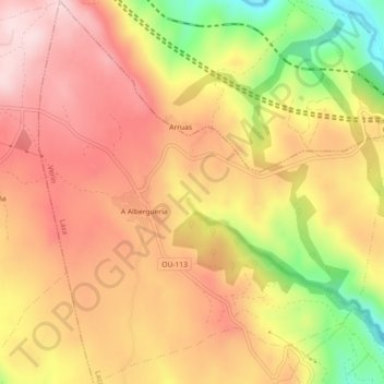
Name: A Alberguería topographic map, elevation, terrain.
Location: A Alberguería, Laza, Verín, Orense, Galicia, España (42.10697 -7.56399 42.14055 -7.52110)
Average elevation: 863 m
Minimum elevation: 665 m
Maximum elevation: 988 m
Other topographic maps
Click on a map to view its topography, its elevation and its terrain.